

The Group
Goostrey Footpaths Group is an informal group of volunteers who work in co-operation with Goostrey Parish Council and Cheshire East Council Public Rights of Way Unit to maintain and improve rural footpaths around the village, making them enjoyable and accessible to all, and encouraging the use of these footpaths.
Our walks are accessible on this website. We also host occasional guided walks around the village – details of which can be found on the website or on social media.
Goostrey is a village and civil parish in the unitary authority of Cheshire East and the ceremonial county of Cheshire, England. Goostrey Parish contains the huge Lovell radio telescope at the Jodrell Bank Observatory which can be seen from some of our footpaths. The Jodrell Bank Observatory is a UNESCO World Heritage site.
The Group always welcomes new members or supporters. So, if you have an interest in our local footpaths or wish to report a problem or make suggestions as to how we could improve our network of footpaths please get in touch via the Contact Us link.
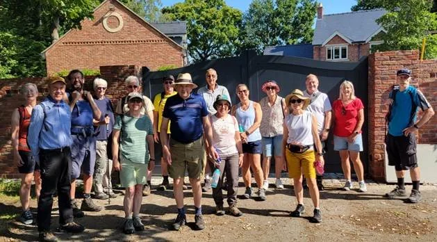
Members of the Footpaths Group and walkers enjoying a guided walk around Goostrey.
Our aims
To promote and encourage the use of the footpaths in and around Goostrey.
To ensure the footpaths are safe and pleasant to use.
To participate in developing new footpaths and in keeping rights of way accessible.

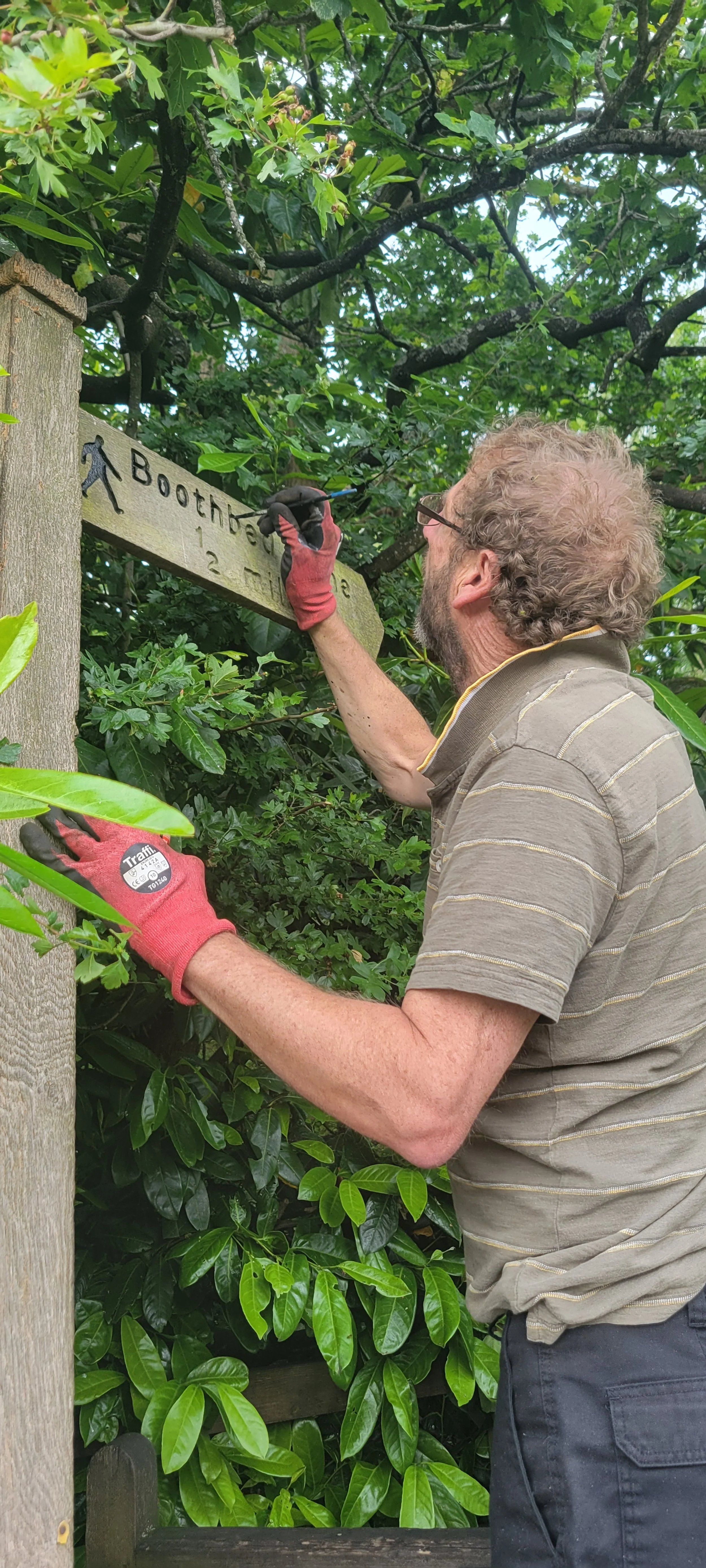
Signage and footpath maintenance
Providing accurate signage is a key focus of the groups work and has been since 1996. Our signage is continually monitored by the group and repairs are undertaken together with new signposts where required.
The signposts tell walkers what they want to know:
Where the path starts.
Where it goes to.
How far it is in miles.
The footpaths in and around Goostrey have become more pleasurable, safer and easier to use thanks to work by the Footpaths Group, other volunteers and the services of Cheshire East Council. We would like to keep it that way. So, if you are out walking on the local paths and encounter a problem please let us know via the Contact Us section on this website and report it directly to Cheshire East Council Public Rights of Way Unit via their website.
The Group takes this opportunity to thank the farmers and other landowners who not only give their permission to carry out improvements, but also offer facilities to make it much easier to implement.
Our history
2025
The new Sibelco Permissive Footpath, linking New Platt Lane to Goostrey Lane, is opened following negotiations with Goostrey Footpaths Group and residents.
Two new linear walks have been included on the website to coincide with Railway 200 celebrations.
2021
A new website went live in September 2021. “More Goostrey Walks and Strolls” can now be downloaded and printed for free.
2020
FP12 – Swanwick Hall. Following the Public Enquiry in February Her Majesty’s Inspector rejected the Application for a diversion so the boardwalk and the route through the old farmyard remain the official route, with the alternative Permissive Path is also available. During the Coronavirus Pandemic our footpaths proved to be very popular with local residents and visitors alike.
2019
Jodrell Bank suggested a route for the new footpath between Goostrey Station and JBO. Discussions continue on the most advantageous route.
The bridge at the eastern end of the Bongs collapsed. The Council arranged repairs and the footpath was re-opened eight days later, fingerposts at both ends of the Bongs were refurbished and re-installed.
2018
Discussions continued with all interested parties on the proposed new footpath between Goostrey Station and Jodrell Bank. Jodrell Bank has concerns about the routing and unauthorised access to their scientific area if a footpath is created.
2017
The Open Spaces Society, supported by the Footpaths Group, submitted an application to re-instate the bridleway known locally as Grassy Lane. This route has always been accessible for walkers and is clearly shown on historic maps.
2016
A full set of the Goostrey Walks publications was lodged with the Goostrey Parish Archive.
The Group gave substantial technical support to the Parish Council in their objection at a Public enquiry to the Application to build 119 houses alongside FP12. The Application was refused.
The fingerposts identifying Grassy Lane vanished, presumed stolen and they will be replaced with new fingerposts.
Discussions continued on the routing of the proposed new footpath between Goostrey Station and Jodrell Bank.
The application to divert FP12 away from historic Swanwick Hall was approved by the Council. This was disappointing for several members of the Footpath Group, as the views of the old Hall would be lost, the Millennium Boardwalk would become inaccessible, and some less agile walkers would find to new route difficult.
2015
Our stand at the annual Goostrey Rose Day continues to be popular with chat about footpaths, bridleways, the countryside and the historic maps on display.
Objections were submitted to a Planning Application for 119 houses alongside Footpath 12.
An application by the Landowner to divert FP12 clear of Swanwick Hall was noted.
The Group donated £500 towards the new Goostrey Scout Hut, and liaison with the Duke of Edinburgh Scheme continued.
Cheshire East Council agreed to a request for the restoration of part of The Bongs foothpath.
2014
“More Goostrey Walks & Strolls” is now almost exhausted with 1,800 sold and just 70 copies left. The new Path North proved very popular.
The status of Grassy Lane continued under review with the Council and the landowner.
2013
Path North was equipped and officially opened on 11 May 2013 following 17 years of negotiation; two footpaths totalling 1½ miles making a safe walking link between the parishes of Goostrey and Peover.
Publications continued to be popular. From a print run of 2,000 just 175 copies of “More Goostrey Walks & Strolls” remained and from a run of 5,000 only 2,200 of the Jubilee Village Map remained in stock.
2012
To mark the Queen’s Diamond Jubilee the Goostrey Village Map, naming all the roads and showing where footpaths linked into the village, was brought up-to-date and a further 2,000 printed.
Discussions with the Council for a new Public Footpath (Path North) to link Goostrey with Peover were successful with the agreement of a route. The Footpaths Group provided four oak fingerposts and some kissing gates for this development. Initial discussions were held with Jodrell Bank (JBO) proposing a footpath link between Goostrey Station and JBO.
Representations were made to Ordnance Survey about the deletion of the Grassy Lane bridleway from their maps.
2011
The removal of fallen trees blocking the Bongs footpath was prompted, plus the repair of the steps and bridge on the path from Goostrey to Twemlow.
It was noted in March that thanks to sterling work by CEC PRoW and the cooperation of several farmers, all paths around Goostrey were in good shape.
The counter installed on the Bongs path (in 1999!) showed that 3,000 trips a year are now made along this path.
2009
With all trace of Grassy Lane almost gone, one of Goostrey’s traditional signposts was installed at each end to mark its route – and to remind everyone to “use it or lose it”.
CCC were alerted to the narrowing of a path in the village by the shift of a fence-line.
At the prompting of the Group, improvements were made to the path skirting the Village Hall, and to the path through The Bongs.
2008
Two stiles on popular paths were replaced by kissing gates, two oak signposts were refurbished by the Footpath Group, and two damaged beyond repair were replaced.
Objection was lodged to the diversion of one of Goostrey’s most popular paths.
2006
The Footpath Group website went live.
As part of “Step into Cheshire Week”, a walk around the local paths, finishing with cream teas at the Village Hall was organised. It was very popular, and was voted 2nd best event of the week out of 50+ events across Cheshire.
2005
Goostrey Footpath Group put on a special display of historic local maps for the Centenary Celebration of Goostrey’s Rose Day. Sales of “More Goostrey Walks and Strolls” passed the 1,000 mark.
2004
The popular path through The Bongs was improved: A Counter on this path shows the week-to-week variation in use, with a peak at bluebell time.
2003
The County’s Concession Path through Galey Wood came into regular use. Installation of kissing gates was completed. A Footpaths Photo Competition was inaugurated.
2002
Replacement of stiles around the village with kissing gates to make access safer recommenced, and sales of the new "More Goostrey Walks & Strolls" passed the 600 mark.
2001
Foot and Mouth disease prevented work on the paths and stopped book sales.
2000
More Goostrey Walks & Strolls Millennium Edition" was published in full colour with new walks, new maps, and 66 colour photos.
1999
Funding for the Millennium Path was secured from Cheshire County Council, Shell, and Manchester Airport; and after extensive consultation with the landowners concerned and with disability groups, practical work commenced. 450 hours of volunteer work went into the project, which included the construction of 48 feet of board-walk across a notorious mud-bath. On 18th September, amid much publicity, the Millennium Path was opened.
1998
A "give away" guide to village road names and the start of all local footpaths was produced and 6,000 copies printed. The Group decided that as a Millennium Project it would revitalise a key local path, to make is suitable for use even by the less agile.
1997
An A3, full colour footpath map in the area was produced for sale, based on nine aerial photographs supplied by Cheshire County Council. Maintenance and improvement of the local paths continued.
1996
Goostrey Parish Council joined the County Council Paths Partnership scheme, to secure funding for the Footpaths Group’s plans. Part of this funding was used to buy oak signposts, engraved with destination and distance, which were installed by Group members at the start of all the Parish footpaths. The first edition of "More Goostrey Walks & Strolls" was published, in black-and-white, with maps and photos detailing 7 walks additional to Dr Rogers’s book.
1995
Goostrey Footpaths Group, an informal team with a dozen members of varying skills - started to meet, and a comprehensive survey of local paths was made.
1994
At the initiative of the Residents Association, a "Footpath Group" was formed.
1993
Goostrey Parish Council organised Footpath Walks, and invited the County Council Footpath Ranger to give a talk in the village.
1992
Goostrey Parish Council and the Residents Association joined forces to make key local footpaths safer and easier to use.
1989
"Goostrey Walks & Strolls" 5th Edition [typed!] went on sale.
1979
Dr Brian Rogers produced "Goostrey Walks & Strolls" - hand-written and photocopied.